Clouds will continue to lower and thicken throughout the rest of the day today. These clouds will significantly curtail any significant warming today with high temperatures of around 25 Degrees. This will set the stage for the accumulating snowfall event to affect the region later this afternoon.
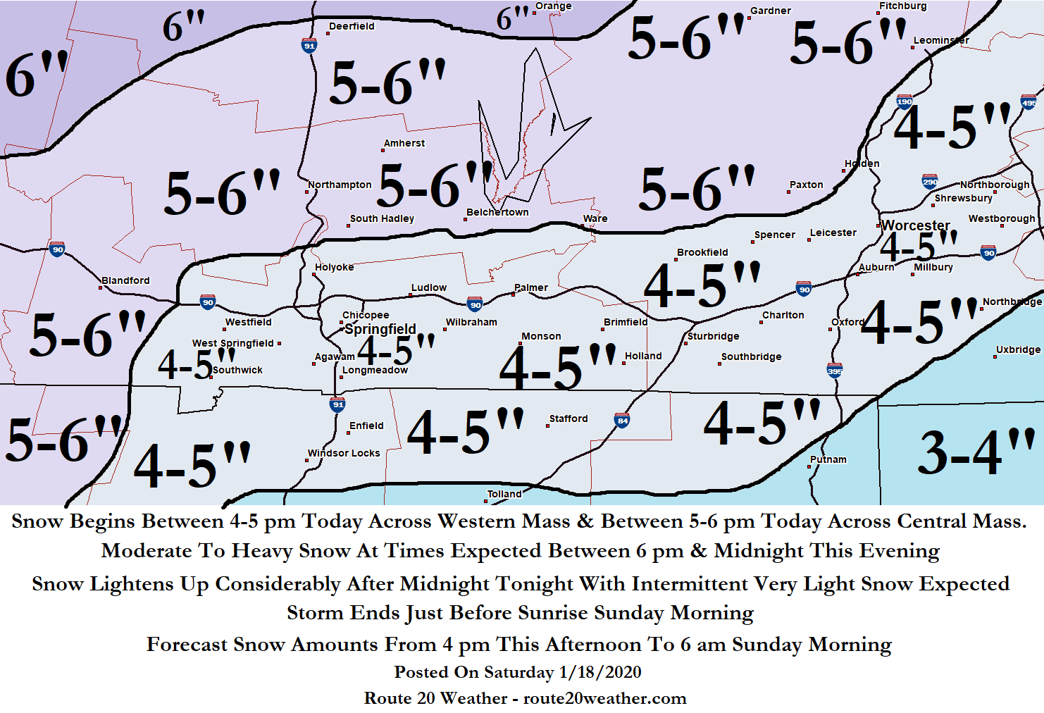
The forecast for the upcoming snowfall event has changed very little & this looks like an almost all snow event thanks to the cold atmospheric conditions. All-in-all, I am still expecting a general 3 to 6 inch snowfall that starts late this afternoon and continues through tonight. The main reason why I’m not forecasting higher snow amounts than this is due to the quick hitting nature of this storm, in which, a majority of the snow will occur in about a 4 to 6 hour time period.
What Time Will It Start Snowing? Snow will overspread Western Mass between about 4 pm and 5 pm this afternoon and then overspread Central Mass between about 5 pm and 6 pm today.
When Is The Worst Part Of The Storm Expected? A majority of the accumulating snow with this storm is expected to occur between 6 pm and 11 pm this evening across Western Mass & between 7 pm and midnight this evening across Central Mass. During this time, moderate to heavy snow is expected to occur with snowfall rates of 1 inch per hour possible at times.
After midnight tonight, the snow will lighten up considerably in intensity with intermittent periods of light snow expected. In fact, some freezing drizzle is also expected at times after midnight tonight.
When Will The Storm End? The storm will come to an end just before sunrise Sunday morning.
Poor Travel Conditions This Evening: It should be emphasized that given the cold temperatures and the expected moderate to heavy snowfall rates, the snow will have little difficulty sticking and accumulating on roads. This means that roads will very quickly become slippery once the snow begins late this afternoon. In addition, poor travel conditions are expected between 6 pm and midnight this evening due to heavy snowfall rates causing poor visibility and very slippery road conditions.
My forecast snowfall amounts can be found with the map below.
Once the storm ends early Sunday morning, we will enter a stretch of dry, but cold weather during the first half of next week with high temperatures in the mid 20s to near 30 Degrees and low temperatures of around 10 Degrees. Some milder temperatures (high temps in the low to mid 40s & low temps in the low 20s) are expected by the end of next week, but it will remain dry.

Follow us on The016.com, the social network for Worcester and you!


